When are we, I ask you? Sometimes we think we know where we are, but we really don't know when we are. - George Carlin, American Comedian, 1937-2008
Ever the astute satirist, leave it to the late George Carlin, an American comedian, to comment on one of humanity's most pressing challenges. How to identify when we are and where we are, and how to express those ideas in visual ways: the building blocks of geospatial mapping.
While Carlin's 1978 joke landed as intended, the comedian wasn't entirely accurate. We really do know where we are. And when we are, too. With exquisite fidelity.

A Humble Start to Geospatial Mapping
Knowing where we are, be it people, physical structures, natural objects, terrain, or the non-spatial and spatial data interrelationships between them, has been a civilizational milestone since about 150 AD. That's when Greek-born Ptolemy published Geographia, the first maps to employ latitude and longitude coordinates for some 8,000 locations.
Since its humble 2nd century beginnings, geospatial mapping has advanced considerably. First, through improved record keeping and more accurate distances between points on Earth. Later, with more precise astronomical calculations, the circumnavigation of the globe, and improved geospatial Technology.
Recent History of Geospatial Mapping
By the 18th and 19th centuries, world maps were starting to look like the ones we know today. Detailed physical maps were being drafted to visualize property lines, county boundaries, demographics and population shifts. In 1832 French cartographer Charles Picquet created one of the first heat maps tracking a Parisian cholera outbreak - an early breakthrough in geospatial mapping.
The Technological Age
After hand-drawn maps came photography, aerial photography, photogrammetry, radar, satellite imagery and 3D laser scanning. All of which added to humanity's ability to visualize and map the world, along with the capacity to overlay geospatial datasets into a single format. First with transparencies and overhead projectors. Then, with increasingly powerful computers creating 3D digital models.

But, What is Geospatial Mapping?
Geospatial mapping is the outgrowth of these developments. It is the interface between visualizing spatial data and non-spatial data (manmade objects, natural objects, and textual/numerical/categorical data) with geolocated coordinate accuracy.

“A spatial visualization method that enables the creation of customized maps to address specific requirements. Its primary aim is to show items with geographic coordinates in a geographical framework, providing a representation of the physical world on a map. Various approaches, solutions, and Geographic Information Systems (GIS) software can be employed to analyze existing geospatial data and geographical and terrestrial databases.” - Imma Mwanj, Data Curator, Virginia Tech University.
The Components that Comprise Geospatial Mapping
Generating geospatial mapping data requires the coordination of several elements:
Hardware - 3D laser scanners, satellites, drones and aerial photographic equipment.
Software - ArcGIS by Esri, QGIS (Quantum GIS) and GRASS GIS (Geographic Resources Analysis Support System) to collect, process and analyze the data.
Spatial data - Vector (geospatial data that represents geographic features as discrete geometric objects consisting of lines, polygons and points) and raster, regularly sized pixels in which each pixel contains information about something on the Earth's surface, like elevation, temperature, or the type of land cover.
Non-spatial data - Surveys, census information, administrative records, business databases, financial reports, sensor data and social media feeds.
People to collect and input data - Useful in crowdsourcing models (Think: Waze).
Geospatial Mapping Today
Today, geospatial data and the software required to process it are everywhere. Google Maps, is arguably GIS's greatest public achievement. Built on the satellite-based global positioning system (GPS), for the first time, the average person could access high-quality maps of every location on Earth. And they could access it in the most user-friendly format, advancing the portable GPS receiver revolution that kicked off a decade or so prior.
Overlayed with that spatial data, Google Maps now includes transit routes, bike paths, real-time traffic conditions, terrain, street views (which combines map data with ground photography visual data) air quality, and wildfires. From our smartphones and tablets to our laptops, desktops and dozens of wearables, pinpoint geolocation is taken for granted.
More than GPS - Geospatial Mapping Applications
So integrated has the science of geomatics become, it's fair to ask, “what isn't geospatial mapping not apart of?” The answer: very little.
Geospatial mapping has found its way into a variety of fields:
Urban planning: Analyzing land use patterns, zoning regulations and urban growth to plan infrastructure development, transportation networks and residential or commercial areas. Additionally, promoting smart city initiatives including intelligent transportation systems and data-driven waste management - something New York City is seeking to pioneer.
Natural Resource Management: For forest management, crop monitoring, precision agriculture and watershed management. Optimizing land use, monitoring environmental conditions, and planning sustainable resource management practices. Hydrologists and water resource managers use it to analyze watersheds, monitor water quality, assess flood risks and manage water distribution systems.
Environmental Conservation and Monitoring: For forest management, crop monitoring, precision agriculture and watershed management. Optimizing land use, monitoring environmental conditions, and planning sustainable resource management practices. Hydrologists and water resource managers use it to analyze watersheds, monitor water quality, assess flood risks and manage water distribution systems.
Transportation Planning: To analyze traffic patterns, optimize transportation routes and plan public transit systems to improve efficiency and reduce congestion. The technology can also track shipments, improve delivery routes and manage inventory in real-time to streamline operations and reduce costs.
Disaster Management and Public Safety: To assess damage, identify areas at risk of structural collapse or secondary explosion, coordinate rescue operations, and allocate rescue resources. GIS also analyzes crime patterns, patrol distribution and identifies criminal hotspots to prevent and investigate unlawful activity.
If the above list isn't comprehensive enough, geospatial mapping is also finding its way into healthcare, tourism, hospitality and real estate.
Geospatial Mapping Technology
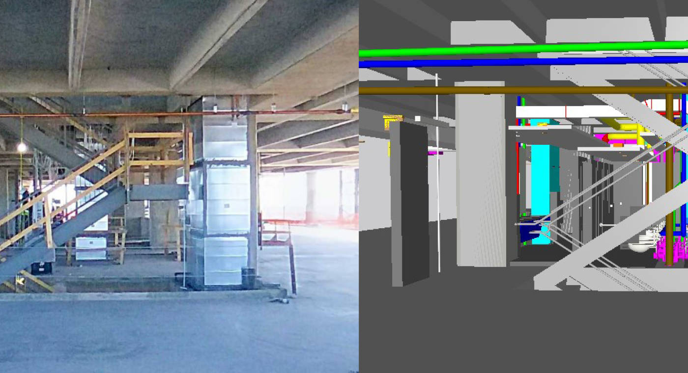
As evidenced from the crime mapping reference, some fields of work have been engaged in geospatial analysis without even knowing it. Likewise, layering a 3-dimensional map with varied data points is essentially, a building information model (BIM). The same holds true with computer aided design (CAD).

LiDAR and Geospatial Mapping
From FARO's perspective, the company's two most geospatial mapping enabled tools are the FARO® Orbis™ Mobile Laser Scanner and the Focus Premium Laser Scanner.
FARO Focus Premium
The FARO® Focus Premium™ is equipped with Hybrid Reality Capture™, powered by Flash Technology™. It is a system which combines the accuracy of a 3D scan with the speed of a panoramic camera. Together this enables the Focus scanner to take fast scans in under 30 seconds with colorized 360° images that save up to 50% scanning time.

FARO Orbis
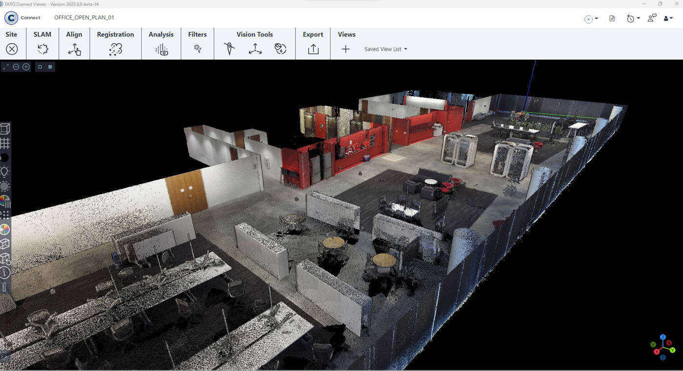
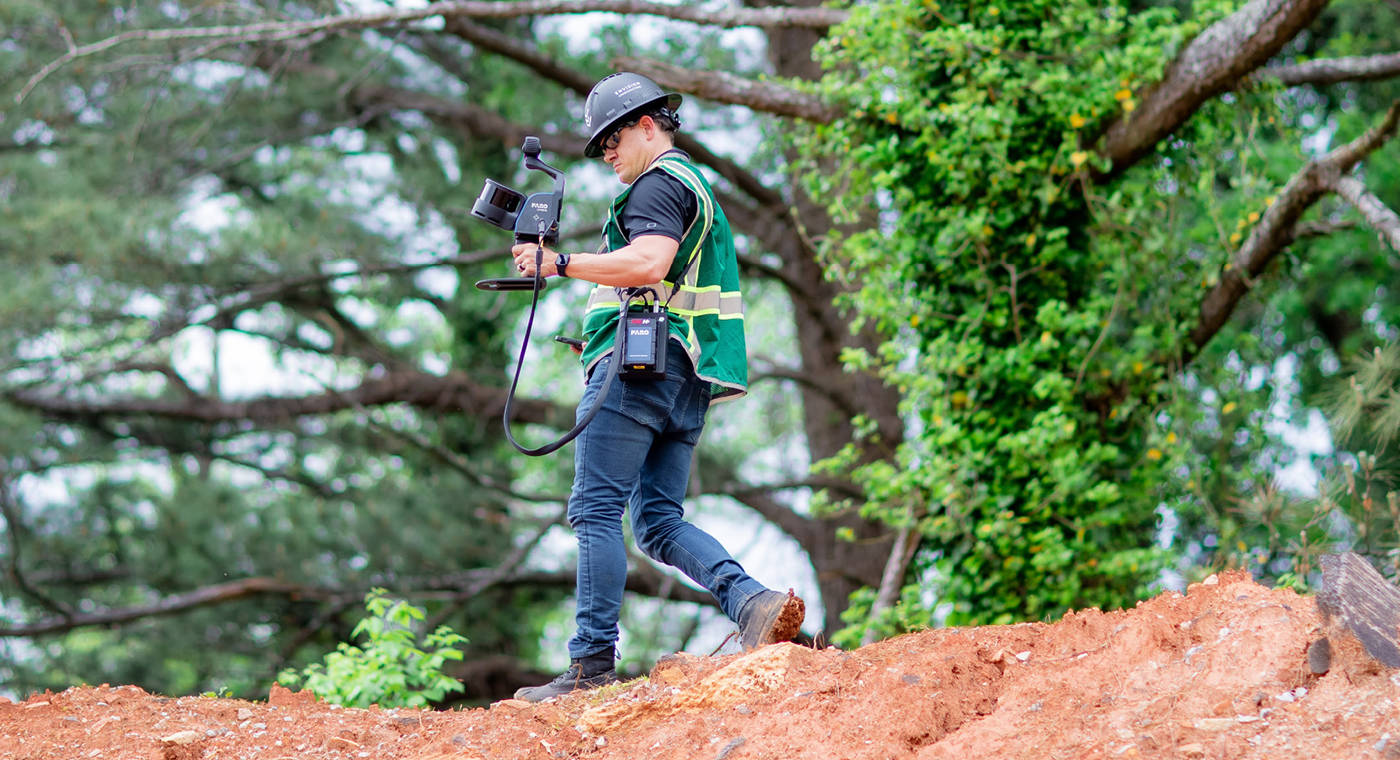
At its core, Orbis is already part location tool thanks to its SLAM (Simultaneous Localization and Mapping) algorithm, which allows Orbis to identify its position to the point cloud it's creating. While not “geo” in that the device is not establishing its latitude and longitude, Orbis has the capacity to georeference data through existing survey control points.

Orbis is a powerful mapping tool for multiple terrains and as-built assets. Similar to how FARO provides the laser scanning component of digital twin technology, Orbis augments the types of maps a complete geolocation system can deliver.
Orbis in Action
One of Orbis' most versatile use cases is in mining . Ideal for overground and underground visual data acquisition, users can capture stockpile volumetric calculations, perform production progress mapping, convergence analysis, or vertical shaft inspection. Tasks such as these reduce risk to human life by limiting exposure to hazardous environments and optimizing mining operations to yield better ROI.
Focus 'in Focus'
The Focus Premium is a related workhorse, eager to demonstrate its geospatial mapping worth. With high levels of accuracy, the Focus scanner is best suited for as-built capture and modeling as well as as-built quality control and infrastructure assessment, including 3D laser scanning equipment for buildings, roads, bridges, tunnels, etc. Focus includes embedded GPS making it an effective tool in merging BIM with GIS, considered one of the next frontiers in the geospatial mapping landscape and why Autodesk considers it “the future of infrastructure.”
The Future of Geospatial Mapping
But if the merging of BIM and GIS is part of the next step in geospatial mapping tech, what's after that? A hint came earlier in this piece with the steps necessary to acquire geospatial information in the first place: People.
At present, geospatial mapping and the GIS systems upon which the geospatial technology relies, remains, to borrow James Kavanagh's words, head of land & resources with the The Royal Institution of Chartered Surveyors (RICS), a “people-centric profession.”
But will that always be so?
Artificial Intelligence
While Kavanagh doesn't anticipate a total robotic takeover, he recognizes that AI-based machines will fill a critical manual labor niche. “[Surveyors] have seen off multiple perceived threats - GNSS, drones, laser scanning, EDM, EO, optical/mechanical instruments - and are adept at taking new technology and customizing it for our surveyors' 'kit bag,’” he writes in an April 2023 article in GIM International. “Robots and AI offer all kinds of possibilities for surveyors, but above all, they can take the hard work out of geospatial data capture and post-processing.”
Beyond Artificial Intelligence
Augmented reality (the merging of computer-generated elements with the real-world environment), digital twins (the real-time modeling of 3D spatial data between a physical asset and its digital counterpart) and lidar-based laser scanners will all continue to advance. Throw in the continued growth of Industry 4.0 and the up to $11 trillion per year Internet of Things economy, and it's clear geospatial mapping will only grow in reach.
Explore and Navigate Your World
Historians generally believe that in addition to the earth coordinates Ptolemy included in Geographia the work also contained an actual map, only that the original has been lost to time. What a wonder it must have been to see that raw data transformed into an image.
Whether we're talking about the world's oldest “modern” map, or we're talking about geospatial mapping, cartography at its heart is about storytelling. It's about giving map readers the tools they need, as Google says in its Google Maps slogan, to “explore and navigate [their] world.”

Today we are privileged to live in a time where our maps are alive. No longer static, dated, dust-collecting things, they've leapt off the parchment and paper on which they were written and have been transformed into their digital offspring. Multilayered, immersive 3D replicas of finely tuned slices of our world, capturing anything we see fit to visualize and measure.
See the Potential
In the final analysis, geospatial mapping's burgeoning potential is best articulated, not by an American comedian, and not by an ancient Greek-born Egyptian who argued in favor of a geocentric solar system. But by the words of Jack Dangermond, the 1969 co-founder of the Environmental Systems Research Institute (Esri).
“I want to have all that scientific information that we're building be used in designing the future so that people who make geographic decisions - and here it's not just land-use planners, but it's everyone: foresters, transportation engineers, people who buy a house - can analyze all of these information layers and design a future.”
Regardless of the technology that underpins its growth, this sounds like a destiny we'd all like to map out.