Bridge inspection – the process of assessing the condition, safety, and functionality of a crossing to ensure it remains structurally sound – is essential for its long-term viability. Failure to conduct such assessments or execute repairs in a timely manner can lead to severe consequences. Fortunately, today’s toolbox for carrying out such bridge inspection tasks is increasingly diverse.
But what is it about bridges that deserve so much fanfare? After all, they are suspended transit corridors, carrying motorists, trains, pedestrians, and elevated subways. We’ve been building them since the rise of the first civilizations. What’s so special about them?
The answer, of course, lies in the symbolism that bridges convey. They connect people and cultures in unique ways. They streamline point A to point B. Built right, they stand the test of time and serve as monuments to our collective engineering prowess.
But to stand the test of time, to become the symbols we cherish, they must be built – and maintained – with exacting precision. Symbolism is great. But cement matters more. That’s where modern technology comes into play; especially 3D laser scanners. Fast, accurate and cost-effective technology is being adopted to augment the bridge inspection process.
What is a Bridge Inspection?
Bridge inspections are a sub-field within infrastructure surveying that addresses the measurement, analysis, and documentation of bridges and their supporting infrastructure. Naturally, it involves the use of surveying techniques and equipment to gather precise data about a bridge’s geometric and structural features, as well as the terrain on which a bridge will be built. Bride inspection is a vital part of infrastructure management, ensuring bridges remain safe and functional.

In general, inspection surveys include various methods; visual inspections, non-destructive testing (NDT) and load testing. 3D point cloud data from laser scanners is an example of such non-destructive imaging solutions.
What are the types of Bridge Inspection?
Structural: Inspection of components like piers, abutments, decks, girders, and support systems. This may involve visual inspections, non-destructive testing (NDT) methods, and measurements of structural elements to identify defects, deterioration, or damage both current and over time.
Topographic Survey: Surveys of the surrounding terrain and infrastructure to understand the landscape, drainage patterns, utilities, and other factors that may affect the bridge design, construction, or maintenance.
Geometric: Measurement of a bridge’s length, width, height, span, and alignment. Surveyors use total stations, GNSS & precise digital levels, and other surveying instruments to collect accurate measurements of these features.
As-Built Modeling: To verify that bridges are constructed according to design specifications and to document any deviations or changes made during construction.
Monitoring and Maintenance: For regular inspections and documenting a digital record of condition assessments, and structural monitoring to identify maintenance needs, prioritize repairs, and ensure the safety and integrity of the structure in question.
Boundary Survey: Involves determining and documenting the legal boundary lines and associated features related to the bridge's location and adjacent properties.
The Complicated Logistics of Bridge Surveying
Of course, bridges vary in style and function. There are overpasses, underpasses, highway flyovers, causeways, cable-stay bridges, suspension bridges, cantilever bridges, and more. Many bridges have underwater components, adding to their complexity. As a result of this diversity, the list of challenges bridge surveyors face is considerable.
Challenges Faced by Surveying Professionals
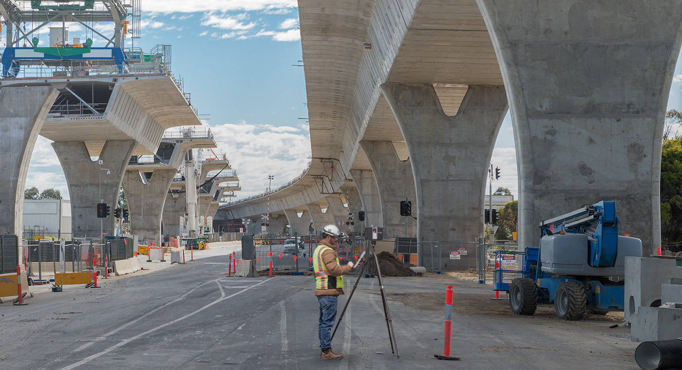
Arguably the greatest challenge is accessibility. By their very nature bridges span difficult-to-access locations – rivers, lakes, bays and other large bodies of water. But even in non-water scenarios, bridges often span deep valleys, which again makes access to mid-sections difficult.
Environmental concerns also rank high. These are, after all, outdoor structures, facing the full force of natural elements. High winds, high water levels, swift currents, vegetation growth, not to mention vehicular and pedestrian traffic, all conspire to make taking physical measurements of a bridge easier said than done.
The “Time and Urgency” Factor
Rounding out the top three challenges, is what might be called the “time and urgency” factor. Especially in high-traffic areas, bridges are the lifeblood of cities and their metropolitan regions, carrying an enormous volume of people, produce and consumer goods.
In New York City, for example, even smaller bridges like the Goethals Bridge, spanning the Arthur Kill waterway (linking the state of New Jersey with the borough of Staten Island), carries some $33 billion worth of goods annually.
Larger, more well-known bridges, like the George Washington Bridge, the world’s busiest bridge for motor vehicles and the only suspension bridge in the world with 14 lanes, carries more than 100 million vehicles per year.
Any long-term closing of structures like these would be detrimental on a reginal, and even global scale, causing supply chain delays and significant disruptions in how millions navigate a large metropolitan area. Worse, any structural failure could result in catastrophic loss of life. In these scenarios time is critical. And every delay in re-opening adds up.
The Modern Approach
Because of these challenges, it’s imperative that modern geospatial technology be brought to bear, including the latest terrestrial laser scanners and mobile mapping tools. Thanks to their speed of data capture, their ability to measure at a distance, and their agility to access hard-to-reach locations, taken together, these devices enable fast diagnosis of the problem, provide the digital 3D data needed to implement (and share via cloud-based platforms like FARO Sphere XG) a solution, and the ability to streamline the entire decision-making process.
Useful Hardware for Bridge Inspection
From FARO’s perspective, the company’s two most bridge inspection-capable tools are the FARO® Focus Premium Laser Scanner and the Orbis™ Mobile Laser Scanner.
FARO Focus Range
The FARO Focus range is up to 400 meters. This is already an advantage when surveying at a distance and in hard-to-reach locations. Combined with a superior onboard camera, the Focus portfolio can capture sections of bridges with poor lighting as well. Multiple HDR settings and customizable resolution and quality settings allow surveyors to select the correct setting for each scan location.
If maximal speed is desired, Focus is also powered by Flash Technology™, a system which combines the accuracy of a 3D scan with the speed of a panoramic camera. Together this enables the Focus scanner to take fast scans with detailed point cloud data in under 30 seconds with colorized 360° images that save up to 50% scanning time.

For surveyors, this means the ability to take accurate measurements and capture all dimensional aspects of a physical structure much faster than traditional methods. Additionally, Focus, with the use of control targets, allows for the capturing of multiple data sets, enabling the monitoring of any changes or movement of the structure.
FARO Orbis Premium
At its core, Orbis Premium is a fast, accurate, Flash-enabled SLAM mobile scanner, with the capacity to georeference data through existing survey control points. For companies that scan hundreds of bridges per year, ensuring their safety, scanning the same structures at set intervals to monitor any movement or changes, scanning a bridge in hours versus weeks can make a significant difference in time and money. Not to mention a reduction in the transit disruption that occurs when a bridge requires maintenance or bridge inspection. SLAM technology also enables the ability to scan areas from a moving vehicle (like a van or boat) showing parts of the bridge not visible with other technologies.

With an accuracy of up to 5mm during a mobile scan and up to 2mm during a Flash stationary scan, structures like bridges, overpasses, and underpasses can be captured with a variety of methods: a monopod for stationary scanning, a car mount for capturing larger areas (driving over a bridge), and a backpack mount for tough terrain, scouting the approach way around the bridge.
Often what you’ll find is Orbis and Focus working together as complementary tools. For the fastest scan of a bridge an Orbis might be the way to go, helping capture the “big picture,” identifying lanes, pedestrian paths, light poles, even cracks of large enough size, providing an overview for stakeholders. For a more detailed look at the utility work, mechanical and electrical, for instance, a Focus and its scan data might be the preferred tool. It’s also useful in determining bridge movement beyond its designed specifications.
Software Synergy
Another way tools like Focus and Orbis work well together is through the third-party software the data is compatible with. This ensures that 3D scan projects can be registered, processed and delivered into various third-party software platforms, as well as the company’s FARO® As-Built™ Software Suite. Compatibility like this makes bridge surveying an easier, more streamlined process.
FARO As-Built Software
FARO® As-Built™ Suite programs are innovative and profitable tools for complete and efficient conversion of reality capture data into CAD and BIM models. As-Built delivers powerful industry-specific functionality for easy, precise, seamless and efficient evaluation. The software suite includes three separate programs in its family of products – As-Built Modeler, As-Built for AutoCAD, and As-Built for Revit. Each program guarantees the most direct workflow from any captured reality data.
Third-Party Compatibility
Like As-Built, third-party software is designed to empower civil engineers to meet complex infrastructure challenges in a 3D model-based environment. Some third-party products can deliver design and construction documentation for road and highway, site design, rail, and bridge projects, all while reducing design time with faster modeling for surfaces, corridors, terrain and more. Others develop software specific for modeling and load-rating analysis on existing and planned bridges. They can also create physical and analytical models throughout the lifecycle of steel and concrete bridges, combining capabilities for modeling, analysis and design.
Additionally, parametric modeling software integrates with civil design applications and leverages enhanced visualization. Software leaders are also beginning to experiment with artificial intelligence, balancing automation and quality to enable teams to extract complex features from point clouds, saving time and money.
Streamlining the Bridge Inspection Process
Perhaps the greatest advantage of upgrading one’s bridge inspection toolkit to 3D laser scanning rests with the ability to tailor your tool for the specific job at hand. Before the advent of devices like the Focus and Orbis, surveyors had to rely on many tools all at once, switching between them depending on what they were seeking to measure.

Focus and Orbis reduce this inefficiency. Orbis offers local processing in the FARO Connect software or cloud-based processing in FARO Sphere® XG Digital Reality platform. Focus, meanwhile, connects with the FARO Stream app for real time, pre-registered visuals, bridging FARO hardware to the FARO Sphere XG cloud environment. What’s more, the pre-registered scans can be fed directly into the cloud, so jobs can be done more efficiently.
From the Verrazano to the Gordie Howe and Beyond
In 2024, the Verrazano-Narrows Bridge turned 60. In the decades since its opening, some 200,000 cars a day cross its 13,700 foot-span. The bridge undergoes thorough inspections every other year, in addition to routine maintenance and upkeep.
A quarter of a continent away, the Gordie Howe International Bridge will link Detroit, Michigan to Windsor, Ontario. Once opened (slated for Fall 2025), it will be the longest main span of any cable-stayed bridge in North America.
Old or new, cable-stayed or suspension, bridges will continue to inspire our imaginations, bridging people, places, things, and ideas. But before a bridge’s collective psychological impact can be felt, it must be inspected, mapped and measured, first.
Only with the most cutting-edge equipment like that offered by 3D laser scanners, can the bridges of yesterday, today, and tomorrow endure.