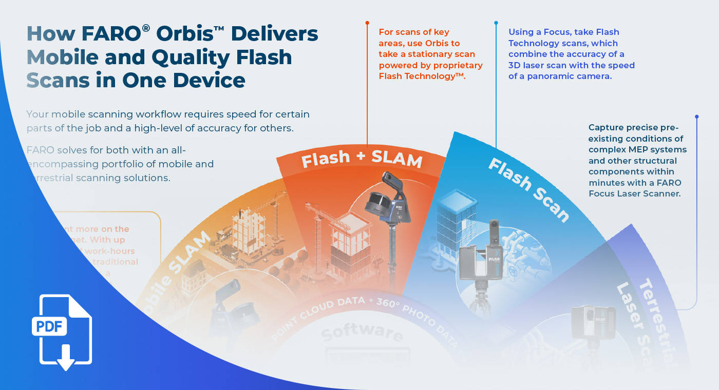
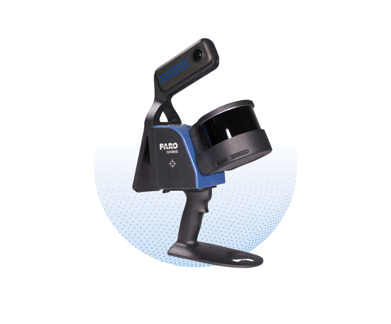
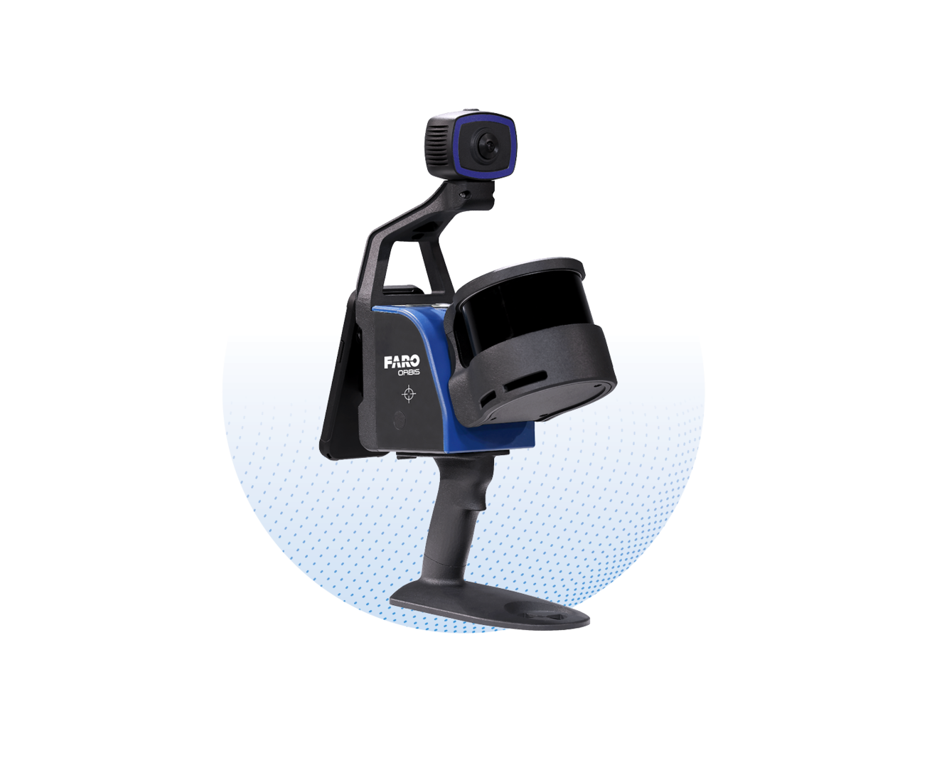
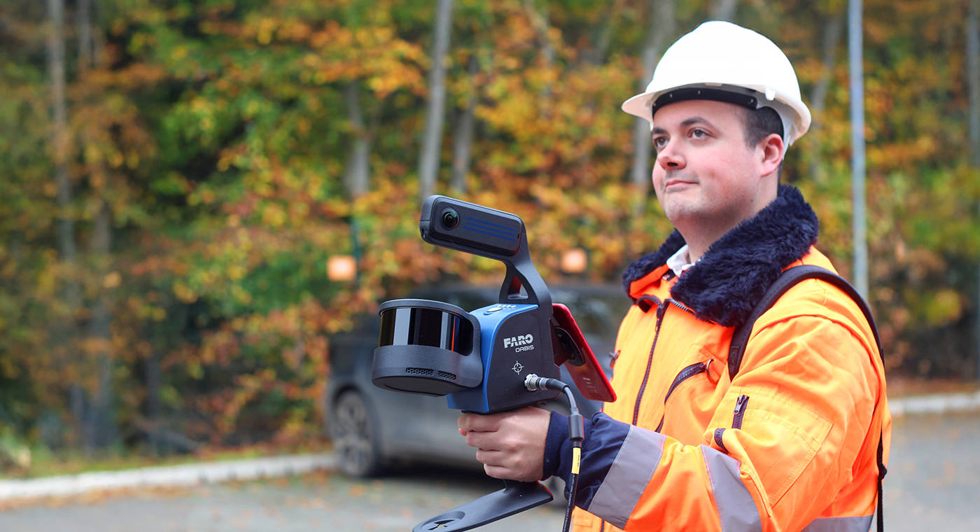
FARO® Orbis Mobile Laser Scanner

FARO Orbis is the all-in-one mobile laser scanner with integrated stationary scanning, powered by FARO FLASH technology.

FARO® Orbis is a unique mobile scanning solution created to optimize workflows and elevate productivity. Designed for construction, engineering and surveying and public safety professionals, Orbis delivers rapid speed of capture, while returning highly accurate 3D visual representations of the real world. Integrating FARO’s Flash Technology in Orbis allows for stationary scans in just 15 seconds and provides unrivaled detail from a mobile mapping solution.

Powered by GeoSLAM’s proprietary SLAM algorithm, it’s the evolutionary step for industry professionals looking to provide highly accurate deliverables faster, reduce human error and magnify overall efficiency. Embrace the power of hybrid mobile scanning with stationary Flash scanning capabilities - elevated by cloud-connectivity with FARO Sphere® XG and embark on a new journey to transform your projects with Orbis – the ultimate companion for modern scanning challenges.

Schedule a Demo
  • Value
  • Features
  • Applications

Business Value of FARO Orbis

Hybrid Reality Capture with FLASH Technology

Improve your mobile scanning quality with Hybrid Reality Capture powered by FARO’s proprietary Flash Technology. Previously unseen in a mobile scanning solution, Orbis offers mobile scanning and stationary scanning capabilities with Flash, delivering high quality, accurate, and dense datasets. These Flash scans can either be shared instantly by uploading them onto Sphere XG seamlessly with the Stream App, or locally offline with FARO Connect®. It’s a combination of speed, data clarity and accuracy in one complete scanning solution.

10x Faster Than Other Surveying Methods

Experience unmatched speed of data capture with mobile scanning technology. Designed for rapid deployment, Orbis ensures fast and accurate data acquisition, revolutionizing your project timelines. It empowers users to capture detailed and accurate spatial data 10x faster than traditional laser scanning, accelerating workflows and ensuring you stay ahead in today’s fast-paced world.

Frequent Data Capture for Better Insights

Capture 3D data more frequently and comprehensively than ever before and elevate your data insights. Stay up to date with fast-paced and evolving scenarios to enhance decision-making and improve collaboration. Ease of use, cloud connectivity to Sphere XG, and portability make frequent and fast data capture possible – a constant stream of fresh insights to transform your projects or quicker turnarounds in sensitive areas like public safety sites.

Scanning Doesn’t Need to be Complicated

Designed with usability in mind, scanning with Orbis is as simple as pushing a button and walking with the device. It simplifies complex surveying tasks, enabling efficient data collection for a broader audience, across various industries. Unlike other scanning methods, minimal training is required to get going with the scanner. The ease of use expands the opportunities for data capture in previously unobtainable or sensitive places.

The World’s Leading SLAM Algorithm

GeoSLAM’s proprietary SLAM algorithm drives Orbis and has been tried and tested in some of the most difficult environments, for over a decade. Constant innovation from customer input has led to the SLAM algorithm that continues to deliver and improve customer projects, in a myriad of industries.

One Year Warranty

We design, build and test our products with quality as a top priority. Because we believe in our hardware, Orbis comes with a one-year warranty as standard. We also offer affordable extended service plans, so you can have peace of mind and prevent unexpected expenses.

FARO Orbis Features

Lightweight and Easy-to-Use

Weighing just 3.6kg(7.93lbs), including the datalogger and battery, Orbis is ideal for scanning large areas fast, without large setups.

Higher Levels of Accuracy

A precision of 5mm during a mobile scan and 2mm during stationary Flash scanning makes Orbis the ultimate mobile scanning solution for high levels of accuracy.

Ideal for Internal and External Mapping

With up to 120 meters in range, Orbis is the ideal solution for both indoor and outdoor scanning, with the ability to seamlessly transition between both.

Best of Both Worlds Processing

Orbis offers local offline processing in the FARO Connect software or optional cloud-based processing in Sphere XG – flexible solutions for processing, analyzing and sharing sensitive data.

360° Photos and Colorized Data

The integrated 8-megapixel camera on the Orbis enables colorized point clouds and additional 360° panoramic pictures.

Engineered for the Toughest Environments

Engineered with the toughest environments in mind, Orbis can easily map places like underground mines, dense forests, crash/crime/fire scenes, or construction sites. Furthermore, it can scan in complete darkness for areas with limited or no lighting.*

The All-in-one Mapping Solution

The Orbis is compatible with a monopod for stationary Flash scanning, car mount for capturing larger areas, backpack for tough terrain, and cradle for descending into vertical shafts or dangerous areas like post-disaster incidents - it is truly an all-in-one solution.

*Colorized point clouds will be impacted by areas captured in darkness or dimly lit areas

Merge Point Clouds, Sync Libraries

Register and merge two scans into a single point cloud with cloud processing via Sphere XG. Ensure an overlap of scanned areas, align, and unify large captures on a single sheet. The 2-way synchronization between FARO Connect and Sphere XG enables you to keep data updated and leverage the advanced viewing options and accessibility of both platforms to create detailed point cloud data.
AEC

The Perfect Tool for Repeatable Data Capture and Collaboration

To ensure your construction projects remain on track, it’s essential to review changes over time. Orbis offers a fast and accurate method of data capture, making it possible to analyze progress on a monthly, weekly or even daily basis without disrupting job-site activities. Easily share your site scans with your team through Sphere XG.
Mining

Rapid Site Information for the Modern Mine

Orbis is an ideal tool for capturing both overground and underground data, thanks to its impressive rate of data capture and range capabilities. You can utilize it to capture stockpile volumetric calculations, production progress mapping, convergence analysis or vertical shaft inspection. By doing so, you effectively reduce risk to human life by limiting exposure to hazardous environments and optimize mining operations to yield better returns on investment.
Geospatial

A Faster Way to Capture Your Data

Orbis offers a versatile scanning workflow, combining fast mobile scanning data acquisition with detailed static scans using Flash Technology. It excels in various applications, including geospatial workflows making it the ideal choice for tasks that demand flexibility and precision. Whether you need fast data capture in dynamic scanning or meticulous Flash scans, Orbis delivers outstanding results, accommodating a wide range of job requirements.
Pre-incident and Security Planning

Leveraging Mobile LiDAR for Pre-Incident and Security Planning

Using Orbis, security professionals can efficiently survey and map complex environments, identifying vulnerabilities and optimizing security strategies prior to potential incidents. The ease of use of the scanner means minimal training is required and repeatable scans for frequent data capture is possible, as often as needed. This proactive approach enables organizations to implement security measures like up-to-date evacuation routes for buildings like schools or hotels.
Large Crime and Crash Scenes

Efficient Data Capture for Crime and Crash Scene Documentation

Unlike traditional methods of data capture, Orbis swiftly covers vast areas with high precision and detail, without the need for a surveying professional due to its ease of use. This minimizes the time required to be on a crime/crash scene, reduces the risks of impacting a scene and provides a clear 3D representation for analysis and documentation. Stationary scanning powered by Flash Technology presents an opportunity for capturing areas of importance faster, with greater detail and accuracy all from one device.
Disaster Recovery

Versatile Data Capture for Disaster Response and Preparedness

Orbis factors in at every stage of the disaster management cycle, including prevention/mitigation, preparedness, response and recovery. The versatile scanner makes data capture of unobtainable areas (with traditional scanning methods) simple. In the event of a disaster, responders can rapidly assess the extent of damage across large areas, facilitating efficient resource allocation and prioritization of recovery efforts. The versatility and handheld nature of Orbis makes post-disaster scanning in precarious areas for planning the rebuilding of infrastructure easy.
3D Capture Device to Match Your Speed Infographics
INFOGRAPHIC

A FARO 3D Reality Capture Device to Match Your Speed and Accuracy Needs

How FARO® Orbis Mobile Scanner, which delivers mobile scans alongside quality Flash scans, fits into a workflow with Hybrid Reality Capture, powered by Flash Technology, and the FARO® Focus Premium Laser Scanner.

Related Products

FARO Sphere® XG

Achieve faster reality data capture and project success through a centralized cloud ecosystem built specifically for FARO service platforms and related applications.

FARO Connect Software

FARO Connect is LiDAR software for data captured from the FARO Orbis mobile scanner, designed to improve efficiency and elevate productivity.

FARO® SCENE Software

With the latest SCENE update, users can benefit from two exciting new features: Interactive Registration and Hybrid Registration for intuitive, efficient 3D point cloud capture and processing.

FARO® Zone 3D Software

The new FARO® Zone 2024 update makes it even easier to create impressive visuals and features FotoPoints, FARO’s new photogrammetry engine, and MassZone Collision Prediction, a feature which automatically recreates accurate collision scenarios without having to enter extensive amounts of crash data.

Recently Viewed Products

Ready to see how mobile mapping solutions can benefit your projects?

Schedule a Demo